

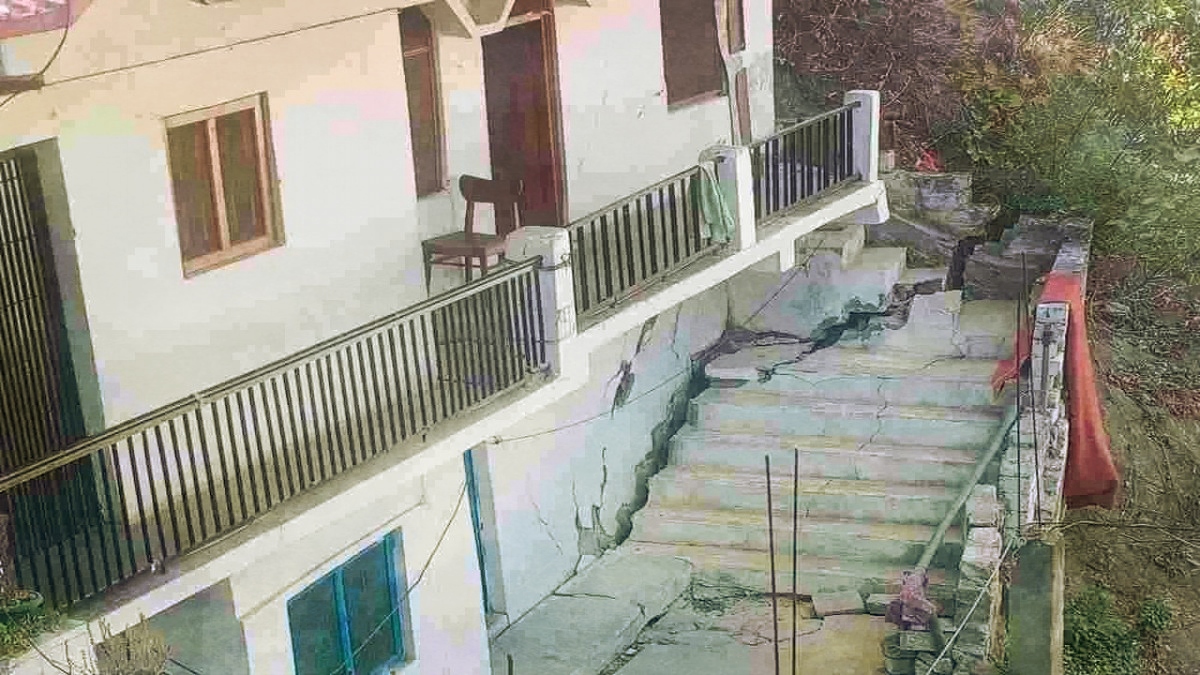
The town of Joshimath in the Himalayan state of Uttarakhand, near the northern border of India, is a gateway to the pilgrimage centres of Badrinath and Hemkunt Sahib and the world heritage site, the Valley of Flowers. It went through a phase of escalated rate of subsidence during November-December 2022, marked by fissures on the ground and cracks in the residential and commercial buildings. This resulted in widespread panic among the local inhabitants and relocation of people, impacting their livelihood.
While most of the southern region of the town experienced moderate to low subsidence, the North and East regions witnessed the worst. The analyses of satellite observations reported by various investigators show that the negligible subsidence in the region was ongoing from January till May of 2022, while it peaked in December.
Also Read: Waiting for Joshimath, or the Need To Restore Tenuous Balance in Fragile Ecologies
An expert committee that includes members of the National Disaster Management Agency (NDMA), the National Institute of Disaster Management, the Geological Survey of India (GSI), the Wadia Institute of Himalayan Geology, and the Central Building Research Institute, among others, investigated the cause of the disaster.
As highlighted in the report prepared by the National Institute of Hydrology (NIH), subsidence happens when the subsoil, which previously held water within its pores, compacts because of the withdrawal of large volumes of water – thus, reducing in size and open pore spaces in the soil. Built on moraine or glacially deposited debris, the soil structure is amenable to the water table’s depletion. As observed elsewhere, ground subsidence resulting from rock mass drainage could range from a few centimetres to several meters. The large altitudinal difference and the soil setting around Joshimath also facilitate a faster gravity-driven subsurface water flow from the recharge areas in the upper reaches to the lower reaches.
The reports in general indicate that the town’s locational setting on morainic debris is a destabilising factor, which is further exacerbated by unplanned and rampant construction in and around the town. The NIH report explains the phenomenon of subsidence is due to the loss of large amounts of groundwater. To quote from the NIH report:
“Land subsidence is one of the most common geomechanical and geotechnical consequences of the loss of a significant amount of groundwater. In general, when large amounts of water are withdrawn, the subsoil compacts, thus reducing in size and open pore spaces in the soil previously held water.”
The conclusion that the Joshimath subsidence is related to the dewatering phenomenon also agrees with the surmise of the team from the National Geophysical Research Institute (NGRI). While these reports underscore soil compaction as a reason for subsidence, due to the dewatering phenomenon, the investigators from the Department of Earthquake Engineering (DEE) at the IIT, Roorkee suggest a mechanism of internal erosion due to excess subsurface flow. To quote from their report:
“The main reason for the subsidence appears to be internal erosion caused by the subsurface drainage, which may be due to infiltration of rainwater/melting of ice/wastewater discharge from households and hotels. They say that although “subsidence is a continuous phenomenon, it can be minimized by controlling infiltration of water, which helps in minimizing the internal erosion.”
While the NIH report focuses on the “loss of significant amount of water” leading to soil compaction as the cause of the sinking of land, the report prepared by the DEE implies excess water infiltration leading to internal erosion within the soil as the causative mechanism. The Geological Survey of India (GSI) also ascribes subsurface erosion to
“piping action locally along a linear zone because of underground seepage lines within the overburden, coupled with an excessively heavy load of multistoried civil structures on a narrow, and potentially unconsolidated debris mass are the main reasons for lessening of shear strengths and increased shear stress of slope forming mass, which ultimately is the instrumental of the recent spurt in subsidence and failure in some parts of Joshimath”.
The study reports submitted recently by various scientific agencies and released by the Uttarakhand government – at the behest of the high court at Nainital – put the blame on the burgeoning population and the overshooting of the carrying capacity of the terrain, offshoots of escalating pilgrim tourism incentivised by the government.
The two study groups representing the NIH and the GSI exonerate the government-sponsored work of the Vishnugad-Tapovan 520 MW hydropower project, which has been in the works since 2004, in their reports. The hydropower project involves the construction of the roughly 12-km long head race tunnel (HRT) 900 metres below the surface. The 8.5-kilometre length of the HRT is being excavated by a Tunnel Boring Machine (TBM) and the remaining 4.9-kilometre length is being excavated by the Drill and Blasting method. Information on how many times blasting has been employed for the tunnel, at what locations and in what quantities is not publicly available.
The TBM got stuck at about 3 kilometres inward of the left bank of the Alakananda River on December 24, 2009, after puncturing an aquifer, causing a huge discharge of high-pressure subsurface water, reported to have been 700 to 800 litres per second and about 60–70 million litres daily. This zone is categorized as groundwater bearing approximately N-S striking steeply inclined brittle faults and fracture zones in a detailed technical paper by Bernard Millen and others, published in 2015. Currently, the water seepage at this point is reported to be 68.20 litres per second. According to the GSI report, the cumulative seepage discharge from the entire 5.9 km long TBM that has been excavated so far is 71.62 litres per second.

The GSI discounts the linkages of groundwater seepage discharge within the tunnel and the subsidence of Joshimath town. The reasons given are the location of the tunnel at 1 km from Joshimath town with an elevation difference of more than 1000 metres and the much-reduced current seepage rate. However, these justifications are not sustainable because we are still ignorant of the vertical and horizontal extent of the highly pressured groundwater-bearing narrow fault zones in the region, including the one that was encountered in 2009.
The current reports have not given due weightage to the potential impact of these instances to cause drastic changes to the hydraulic properties and increased permeability – not only at the immediate location, but in neighbouring and even distant areas. The tunnelling was stalled also in February 2012, September 2012 and sometime in 2020 resulting in long intervals of intermittent suspension of the work. It is not known if these incidents are a repeat of the 2009 event. The puncturing of aquifers may have led to the gradual depletion of pore pressure within the sediment leading to aquifer compaction and settling of the ground. The role of pore pressure in determining slope stability needs to be studied further in this region to reach the bottom of the crisis in Joshimath.
What triggered the accelerated subsidence in some parts of Joshimath? Whether it resulted from excess infiltration of surface water leading to internal erosion or it’s because of soil compaction due to groundwater depletion remains a live question.
C.P. Rajendran is an adjunct professor at the National Institute of Advanced Studies, Bengaluru.