

Before the heights of mountains are measured, whether on Earth or on extraterrestrial worlds, geodesists must first determine where a mass of water would come to rest on that body.
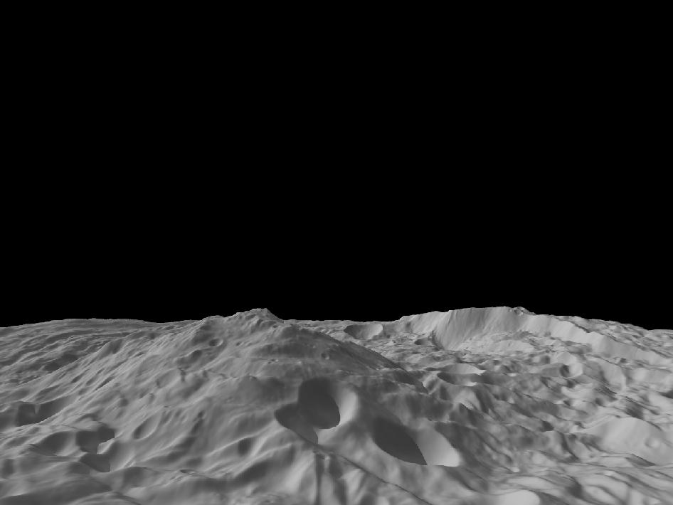
If you loved trivia as a child, your answer to what the tallest mountain in the Solar system was would’ve been Olympus Mons on Mars. It is a flattened-out, 21.9-km high volcano that resembles a giant pancake, with gentle slopes that rise above a sharp, jagged circumference. This isn’t surprising, considering Mars has low gravity and so enables mountains to grow taller. Naturally, it follows that something with even lower gravity will have even taller mountains. And if you’ve been following the latest developments in astronomy, you would now know that the title of the tallest mountain in the Solar System now belongs to the peak of the Rheasilvia crater, a mound with steep slopes that disappears into the heavens on the protoplanet Vesta, in the asteroid belt between the orbits of Mars and Jupiter. The peak of Rheasilvia is 22 km high, barely 100 m taller than Olympus Mons.
Contrast these peaks with those on our Earth: Mauna Kea, in Hawaii, technically 10.2 km from base to top, is considered to be only 4.2 km high as the rest of the shield volcano is underwater. Denali (formerly McKinley) in Alaska is the tallest mountain at 5.5 km to be entirely on land from base to peak. Mount Everest’s peak is at a 8.8 km, but the distance is measured from above the sea level, making it the tallest peak on our planet.
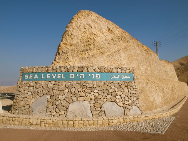
The height (or depth) of any feature on a body is measured as the distance from sea level. This is necessary because bodies in our solar system are not uniformly or smoothly spherical. There are different points of elevation in different regions, which gives rise to different altitudes and air pressure. To be able to standardise this measurement of elevation and depression, on Earth, we have a system where we measure the height of any point as a distance from sea level. New Delhi, India’s capital city, is 216 m above sea level. Coachella, the popular musical festival venue in California, fully lies 2 m below the sea level.
But that doesn’t mean Coachella is submerged. The sea level on our planet is not uniform as our planet’s surface is not uniform. As a result, different countries and continents have different altitudes at which their shores lie. This is because of a multitude of reasons, starting primarily with Earth’s shape.
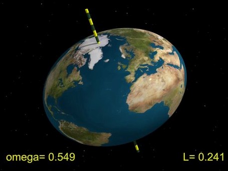
Earth is not a perfect sphere as is often portrayed. Due to its spinning, the equator bulges out and the poles flatten down – just a bit. So the diameter across the equator is much more than the diameter across the poles – by 42 km to be precise, and Earth’s ideal shape is defined as an oblate spheroid.
As continents drift and move about, they cause changes in sea currents and displace voluminous amounts of water. Since they are so massive and heavy, they also have gravity, and the gravity of continents pulls more water toward itself, increasing the sea level near themselves and lowering it out in the middle of the oceans. The currents caused due to winds also change sea levels perennially at any point. Additionally, factors like the salinity of water, atmospheric pressure, temperature, etc., also contribute to the lack of uniformity of the water level. And altogether, the result is that sea level is not and can’t be uniform all over Earth.
To simplify the process, geodesists – those who mathematically model and study the shape of Earth – use a reference line called the mean sea level (MSL). It is measured by taking the average of high tides and low tides in an area over a period of time. But here’s the thing: this reference line isn’t a sphere around Earth, constant everywhere, but varies from country to country because the sea level varies from country to country! So California’s MSL does not lie at the level of Delhi’s. And this difference across regions is factored into the build of satellites and navigation systems so that they stay perfectly on course.
But getting back to Olympus Mons on Mars, we face an interesting dilemma. How do you measure sea level on a planet that has no seas? The most intuitive thing to do would be to figure out what could possibly make for a hypothetical sea level. So we search for a patch on the surface where the terrain is smoothest. Naturally, there’d be regional variations because Mars (and any other rocky body) has an uneven surface, often displaying the same localised gravitational differences Earth does. The process is simplified by using a reference shape, like Earth’s oblate spheroid. Such an approximation for a body is called a reference ellipsoid. These ellipsoids are smooth and even on the surface; all elevations and depressions are measured from this hypothetical sea level.
Such a process is relatively simple when a body is near spherical. So for the Moon, Venus, and Mercury, the reference ellipsoid is an approximation of a smooth body, where the radius is equal to the average surface height. That means all the peaks and depressions are measured, and then their mean is taken to be the radius of the reference ellipsoid and therefore the surface or the sea level.
However, for bodies with large craters, plate tectonics and any kind of noticeable disfiguration on the surface, obtaining this smooth surface is tough. Instead, you’d have a completely plain plane but atop a wide, flat mountain – Mars has a multitude of such volcanoes and mountains. So astronomers went one step further with Mars and decided to fix the sea level at an altitude where water would rest had it been present.
Not so fluid a reference
Water is capable of existing in three states: solid (ice), liquid water, and gas (vapour). However, at a specific value of atmospheric pressure called the triple point, water can exist in all three states. Since Mars has an atmosphere, albeit a thin one, a mathematically easy solution was found in fixing the sea level of Mars at the triple point of water. This habit carried on for years till we started exploring more irregular bodies and the geodesy reached new heights.
Not all bodies are spherical or even regular. Irregular bodies like asteroids, dwarf planets, comets and other minor planets have bumpy surfaces, making it harder to find a simple approximation of the body’s shape (quick note: anything that is not a planet or a comet is called a ‘minor planet’, including asteroids and dwarf planets). To understand where the hypothetical sea level should be on such entities, we turn to our own planet once more.
Satellite technology has enabled geodesists to accurately model a ‘truer’ shape of Earth called a geoid. This is the shape Earth would take had the oceans been still, with no currents, winds, pressure, salinity or temperature differences.
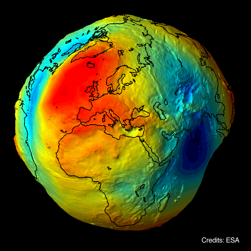
This is necessary because water tends to fill up depressions and crevices. To find the true sea level, it’s important to assume that the water is still without the usual external forces acting on it. Essentially, it’s the result you’d get should picture Earth as a rocky body with no water but all the bumps, and then imagine the oceans being poured onto this body and figuring out where, and how, the water would settle. The most important thing about the geoid is that it is an equipotential surface. When you say ‘potential difference’, you think of electricity and how it flows from higher to lower potential zones. In an equipotential system, there is no flow; on an equipotential surface, water remains still.
Discounting external factors leaves this model accounting for Earth’s rotation and its gravity as a planet. But we do not know the geoid well enough to standardise this model and use it globally yet, primarily due to the large quantities of water on our planet.
On the other hand, smaller bodies like Vesta and Mars are easily visitable by spacecraft that can bounce light and sound off the surface to map it. Mars has had numerous orbiters and Vesta has been completely mapped by NASA’s Dawn spacecraft. Thus, scientists were able to determine the geoid of these bodies with sufficient accuracy to use them as standard reference frames. And the equipotential surface of the geoid for these bodies is considered to be the sea level from which to measure elevations and depressions.
As it happens, geoids are also used to mark latitudes and longitudes, making location-tracking and zoning-in more accurate. It’s essentially a 3D map of the whole planet with room for changes shaped by gravitational forces. This raises an interesting question: What are geoids like for gaseous planets like Jupiter and Saturn? Again, the geoid’s surface on Jupiter or Saturn is the surface at which water would rest, along a hypothetical sea level. Since these planets are made of gas, our reference frame becomes a factor of pressure; the geoid of gaseous planets is the approximate radius from the centre where the atmospheric pressure is 1 bar, just a little less than the resting atmospheric pressure at sea level on Earth.
Sandhya Ramesh is a science writer focusing on astronomy and earth science.